Turning weather information into farming decisions
Estimated reading time: 5 minutes
Agricultural producers across South Africa regularly make management decisions influenced by changing weather conditions, whether preparing livestock for heat stress, planning irrigation after rainfall, or managing fire risk during dry periods. Access to clear and practical weather information can make these decisions easier, yet such information is not always available in a form that is easy to interpret at the farm level.
To help address this need, the Agricultural Research Council (ARC) has developed the Weather Risk app (available at www.weatherrisk.arc.agric.za), a free web-based tool that brings together key weather and water availability information for South Africa in a single interactive interface.
Introducing the Weather Risk app
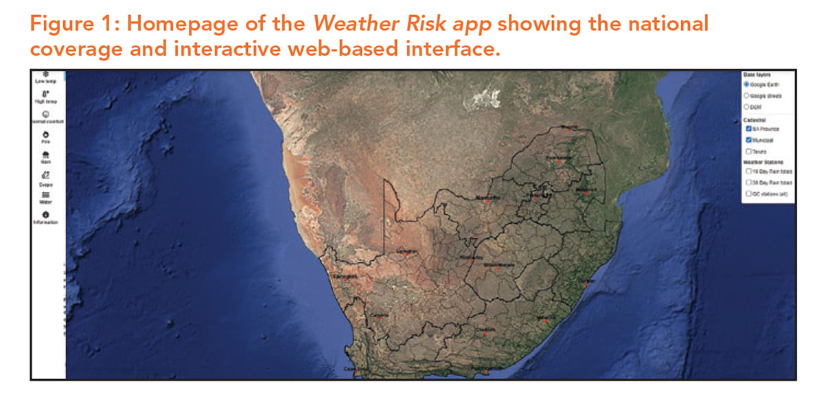
The app was developed by the ARC, with scientific input from the Agrometeorology Division alongside systems developers and researchers from the Water Science Division. It is freely available online and can currently be accessed via a desktop computer. It provides national coverage while allowing users to explore conditions at local farm level scales within the interface (Figure 1).
It combines observed weather and water-related data with short-term forecasts, enabling users to assess current conditions and potential risks.
Designed with practical decision-making in mind, the app supports extension officers, agricultural advisors, producers, and others who require accessible and reliable information for planning and risk management. Although designed with simplicity in mind, guidance on navigating and using it is available in an online user guide downloadable from www.github.com/climindex/hydroclimsa/blob/main/App_user_guide/Weather_Risk_app_user_guide.md#weather-risk-app-user-guide.
From information into insights
The Weather Risk app presents weather and water availability information as indices, designed to make complex data easier to interpret.
An index summarises weather or water conditions over a defined period into a single, meaningful measure, helping users quickly understand developing conditions without having to interpret individual daily values.
For example, weather data can be summarised into indicators showing when livestock may begin to experience heat stress or when meteorological conditions increase the likelihood of veld or crop fires. Instead of analysing multiple weather variables separately, the app translates this information into practical indicators that highlight conditions relevant to everyday farming activities.
Numerous indices are available in the Weather Risk app, based on observed weather and water-related data and short-term forecasts. These indices help users identify conditions such as livestock heat stress, elevated fire danger, and other weather-related risks that may influence farm management decisions.
Figure 2 shows examples of two indices available on the Weather Risk app for 25 February this year.
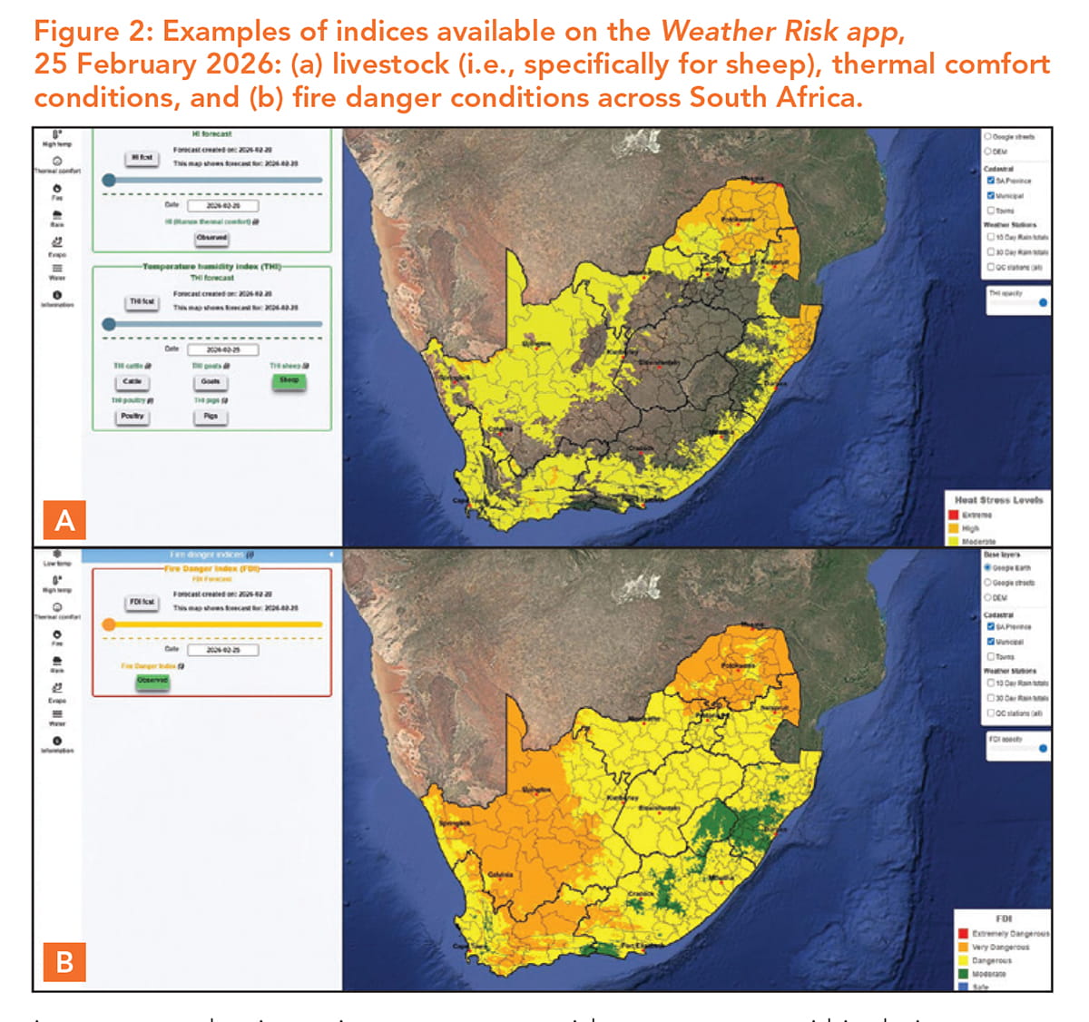
The livestock thermal comfort index, shown here for sheep, highlights the conditions under which animals may begin to experience heat stress, while the fire danger index classifies conditions according to increasing levels of fire risk. Displayed across South Africa, these indices allow users to quickly identify areas where increased awareness or management action may be required.
A practical example
Weather and water availability information is most useful when it can support practical decisions on the ground. Observed indices in the Weather Risk app help users understand recent conditions, allowing producers and advisors to assess current impacts and adjust management as needed, while forecast-based information enables them to anticipate conditions in the days ahead and plan proactively.
Several forecast indices are available in the app, and when considered together, they can provide a more complete picture of developing conditions and potential risks.
Figure 3 shows the daily potential evapotranspiration forecast for 28 February 2026 (day one of the forecast), indicating expected atmospheric water demand under forecast weather conditions. Higher potential evapotranspiration values indicate greater moisture loss from soils and plants, which can signal increased irrigation needs and faster drying of grazing areas.
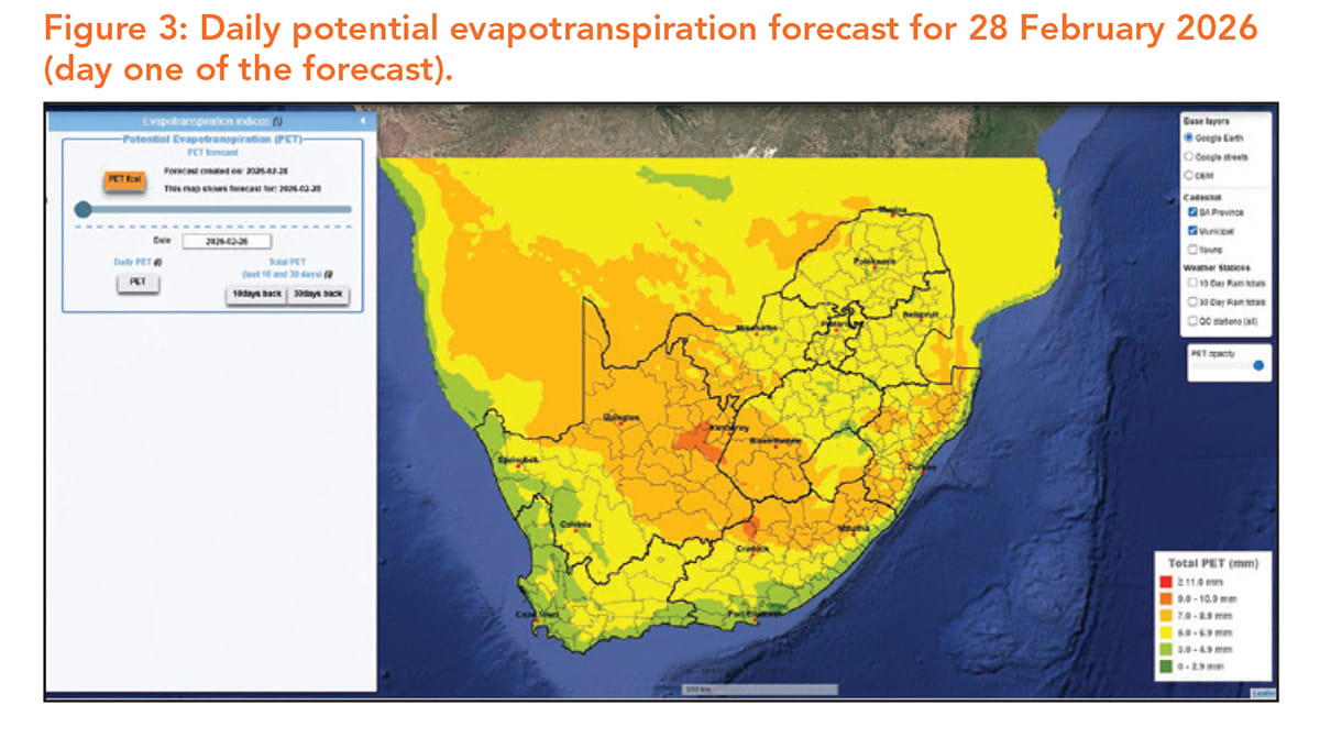
Information like this can support short-term planning and risk reduction by helping crop producers adjust irrigation scheduling and anticipate crop water stress, while livestock producers may use the same information to prepare for declining pasture moisture or increased water needs for animals. By presenting both observed and forecast information in a clear, accessible format, the Weather Risk app supports more proactive, informed decision-making for weather-sensitive agricultural activities.
Built with users, and still growing
The Weather Risk app has been developed with input from stakeholders across the agricultural sector, including producers, extension officers, and other users of weather and water information. Feedback received during development has helped shape the app’s design and functionality, ensuring it remains practical and relevant for real-world decision-making. Although the app is ready for wider use, ongoing feedback is encouraged as it continues to evolve through additional user input.
Planned enhancements include user login and customisation features, alert functions, additional indices, and continued refinement of existing tools. As the app grows, opportunities for long-term sustainability and potential commercialisation are also being explored to support ongoing development and expansion.
Readers are encouraged to explore the Weather Risk app and consider how it may support planning and risk management within their own operations. Feedback remains an important part of the app’s development and can be provided directly through the online questionnaire available at www.forms.gle/z2aSdZhHvhPqwRHh7.
By making weather and water availability information more accessible, the Weather Risk app aims to support more informed, proactive decision-making across South African agriculture amid variable weather conditions. – Dr Sarah Roffe, ARC-Natural Resources and Engineering
Acknowledgments
The Weather Risk app was developed by the ARC with financial support from the Water Research Commission (WRC) under the project Development of a climate and water availability indices app to support decision-making across South African water management areas (project number C2023/2024-01182). The views expressed in this article are those of the author and do not necessarily reflect those of the ARC or the WRC.
For more information, send an email to Dr Sarah Roffe at roffes@arc.agric.za