
How groundwater levels respond to rainfall in the Sandveld
Estimated reading time: 9 minutes
Water resource management has been extensively examined over the years and has become an increasingly prominent area of focus in the past decade. In semi-arid countries such as South Africa, rising water demand coupled with already over-allocated water rights has heightened conflict and frustration among groundwater users (Van Wyk et al., 2006).
These long-standing challenges are now compounded by the uncertainties introduced by climate change, which directly and indirectly affect the hydrological cycle and all of its components (Tian et al., 2018). Semi-arid and arid regions are particularly vulnerable due to growing atmospheric moisture demand and observed increases in temperature extremes (Tian et al., 2018; Dorjsuren et al., 2018).
Over the last 20 years, South Africa has experienced more frequent and extreme weather events, including intense rainfall and prolonged droughts (Du Plessis and Burger, 2015). The magnitude and timing of these events continue to change and are expected to do so in the future (Du Plessis and Burger, 2015; Pabaghi et al., 2023; Trenberth et al., 2003), with significant implications for aquifer recharge and long-term water availability.
One of the most damaging droughts recorded in the Western Cape occurred between 2015 and 2018 (Otto et al., 2018). This multiyear drought severely affected South Africa’s agricultural sector, which relies heavily on rainfall and surface water for irrigation. During the drought, irrigation allocations were reduced by 60 to 86% to avert a worst-case scenario (Pienaar and Boonzaaier, 2018).
These restrictions, combined with dry conditions, led to substantial crop losses and financial implications estimated at around R14 billion in 2018 (Otto et al., 2018; Theron et al., 2021).
The drought highlighted the critical role of groundwater as a buffer during periods of rainfall shortage, particularly in regions where agriculture is a dominant economic activity.
Importance of the Sandveld
The Sandveld, located along the Western Cape’s semi-arid West Coast, is characterised by high variability in rainfall, temperature, and agricultural intensity (Munch et al., 2013). Several catchments within tertiary catchment G30, specifically Verlorenvlei, Papkuils, Langvlei, Jakkals and Sandlaagte, have some of the highest proportions of land converted to rainfed agriculture in the country (Van Niekerk et al., 2018).
Agriculture is assumed to be the leading water consumer within these systems, accounting for more than 90% of total water demand (Archer et al., 2009). This strong dependence on water makes the region’s economy very vulnerable to changes in climate and water availability.
The Sandveld is a key agricultural hub, especially for potato production, contributing roughly 15% of South Africa’s annual potato supply.
Around 93% of this production consists of table potatoes, with the remainder grown as seed potatoes.
Although the total area under potato cultivation has stabilised in recent years, concerns persist regarding the long-term sustainability of groundwater use for irrigation.
The region also supports citrus and table grape industries, particularly in the coastal and upland zones, all of which rely heavily on groundwater. As part of ongoing efforts to understand groundwater behaviour in the region, Potatoes SA completed its 21st consecutive annual groundwater monitoring round in February 2025. This long-term dataset is invaluable in assessing the effects of climate variability on groundwater resources.
Fluctuations in rainfall and temperature have increased uncertainty about surface water availability across the Sandveld. As a result, producers and water users have grown more dependent on groundwater, particularly during droughts or when surface water sources fail to meet irrigation demands. This has intensified the need for a detailed understanding of the region’s hydrogeological systems and groundwater dynamics.
Hydrogeology of the Sandveld
The Sandveld’s hydrogeological framework consists of three main aquifer systems: the primary Sandveld aquifer, the secondary Table Mountain Group (TMG) aquifer, and the semi-confined secondary Malmesbury Group (MG) aquifer (Miller et al., 2022). Research by Miller et al. (2022) and Watson et al. (2018) shows that these aquifers are at least partially interconnected, and that understanding how groundwater moves and mixes among the different aquifers is essential for evaluating groundwater resource evolution in the region.
Each aquifer within the Sandveld region receives recharge from different sources, either directly from rainfall or indirectly through lateral groundwater flow from adjacent aquifers. The secondary TMG aquifer receives recharge directly from rainfall, primarily where TMG fractures outcrop in mountainous areas such as the Piketberg. In contrast, the MG aquifer, which is overlain by thick successions of unconsolidated sediments, is primarily recharged from the adjacent TMG aquifer via fractures (Watson et al., 2018).
The primary Sandveld aquifer is unconfined and can be recharged directly by rainfall; however, it is located in a much drier region. As a result, this aquifer is primarily recharged laterally from the secondary TMG aquifer, allowing groundwater to flow from the mountainous areas through open fractures into the thick sediment successions of the Sandveld (Watson et al., 2020).
Due to the differences in recharge processes and pathways between the aquifers, groundwater-level responses to climate variability and abstraction stresses may differ, and a lagged response in groundwater levels to climatic variability may therefore be expected.
Rainfall/groundwater interaction
To explore the relationship between climate variability and groundwater behaviour in the Sandveld, ten years of rainfall data and ten years of groundwater level (hydraulic head) observations were analysed, with a particular focus on the 2015 to 2017 drought (Figure 1). The Department of Water and Sanitation Hydstra database, in conjunction with the GEOSS database, was used to source groundwater level data for the observation boreholes.
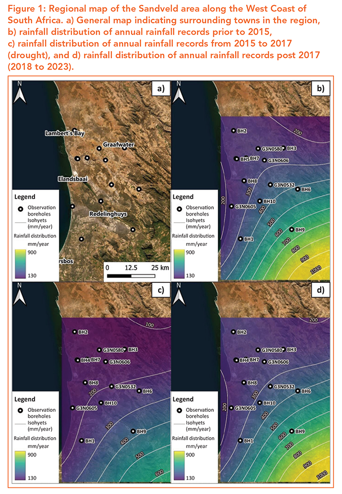
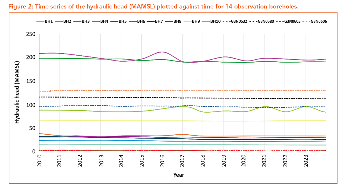
Time series were developed for each borehole showing the change in hydraulic head in metres above mean sea level (MAMSL), from 2010 to 2023, to identify any short- or long-term trends that aligned with fluctuations in rainfall.
Despite expectations that groundwater levels in the primary aquifer might show a noticeable response to the severe drought, no clear or consistent spikes or drops in hydraulic head were observed across the boreholes. The groundwater trends did not visibly mirror the rainfall record, suggesting a more complex or buffered hydrogeological response (Figure 2).
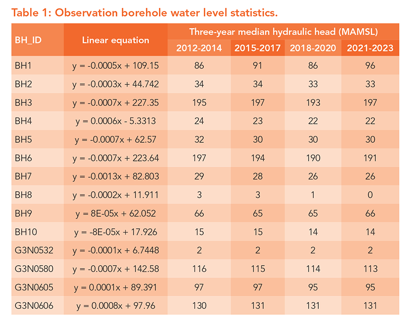
In addition to time-series analysis, hydraulic head measurements from all boreholes were plotted over time, and regression lines were fitted to evaluate the overall direction and magnitude of long-term trends.
Most boreholes exhibited negative slopes, indicating a gradual decline in groundwater levels over the study period. However, the magnitude of these declines was small, with average slopes around -0.0002, suggesting only minor long-term decreases in hydraulic head (Table 1).
The absence of a strong correlation between rainfall patterns and groundwater levels may reflect several underlying factors. These include delayed recharge processes, diffuse infiltration pathways, or the integrative nature of the aquifers, which may buffer the system against sharp rainfall fluctuations. Alternatively, the small but consistent negative trends may indicate the influence of sustained abstraction rather than direct climatic effects.
Recharge sources and implications
The weak correlation observed between local rainfall variability and hydraulic head responses in the Sandveld is consistent with previous geohydrological investigations into regional recharge processes by Conrad and Gend-Muller (2019).
Isotope and chloride mass-balance studies conducted as part of long-term groundwater monitoring in the Sandveld indicate that recharge within the Sandveld itself is limited. Recharge rates are typically below 5%, with only 5% of annual rainfall reaching the saturated zone.
In contrast, significantly higher recharge rates (>15%) occur in the surrounding mountainous areas, particularly the Piketberg and Cederberg regions, which host the TMG aquifer.
Stable isotope signatures further demonstrate that groundwater abstracted in the Sandveld is predominantly derived from higher-altitude rainfall rather than local precipitation. This strengthens the findings of Watson et al. (2020) and Miller et al. (2022), who proposed that the aquifers are interconnected and recharge from higher-altitude areas such as the Piketberg mountain.
This spatial disconnect between groundwater recharge and abstraction areas provides a plausible explanation for the buffered groundwater responses observed during the 2015 to 2017 drought. Groundwater responses exhibit a longer lag time compared to surface water systems, effectively smoothing out the short-term impacts of rainfall variability (Moseki, 2018). However, this does not imply that groundwater resources are immune to long-term rainfall variability (climate change).
Groundwater may buffer droughts, but sustained abstraction and reduced recharge risk long-term declines, quality degradation, and reduced baseflow (Swain et al., 2022). This underscores the importance of managing abstraction pressures not only in the Sandveld but also within critical recharge zones upstream.
Long-term water security
The findings highlight both the resilience and vulnerability of groundwater resources in the Sandveld. The aquifers appear to buffer short-term climate shocks, as evidenced by the absence of major declines during the 2015 to 2017 drought. However, the persistent, albeit small, downward trends suggest that cumulative abstraction and/or the buffered rainfall effect may be placing pressure on the system.
Given the region’s reliance on groundwater for potatoes, citrus, and table grapes, even modest long-term declines could have significant implications for agricultural sustainability. As climate variability increases, groundwater will remain a crucial resource. However, its long-term viability depends on careful monitoring and management to ensure it serves as a reliable alternative during droughts and periods of reduced rainfall.
Conclusion
The Sandveld is a critical agricultural region in the Western Cape, relying heavily on groundwater to sustain economically important crops, including potatoes, citrus, and table grapes. While the recent droughts highlighted the importance of groundwater as a buffer for agricultural production, the relationship between rainfall variability and groundwater response is not straightforward.
Groundwater can act as a buffer, but if there are repeated droughts and increased abstraction, it can push the water resource past recovery thresholds.
These insights underscore the need for continued groundwater monitoring and proactive management strategies. As climate variability intensifies, understanding the behaviour of the Sandveld’s interconnected aquifer systems will be essential for protecting the agricultural sector and ensuring sustainable groundwater use into the future.
Ter opsomming
Die Sandveld is ’n belangrike landbougebied wat 15% van Suid-Afrika se aartappels lewer, tesame met beduidende sitrus- en tafeldruif-oeste. Omdat die streek semi-droog is en oppervlakwater dikwels tydens droogte beperk word, soos die 60 tot 86% besproeiingsnitte tussen 2015 en 2018, het produsente bykans totaal afhanklik geword van grondwater.
Navorsing toon dat grondwater in hierdie area nie hoofsaaklik van plaaslike reën afkomstig is nie, aangesien die meeste daarvan verdamp of afloop. Die grondwater word eerder aangevul deur reënval in verafgeleë berggebiede soos die Piketberg. Dié water beweeg stadig deur ondergrondse breuke in die Sandveld se sanderige waterdraers. Die ondergrondse vloei skep ’n natuurlike ‘buffer’ wat die boerderygemeenskap teen onmiddellike reënvaltekorte beskerm.
Langtermynmonitering bied egter rede tot omsigtigheid. Hoewel boorgatvlakke nie tydens die onlangse droogte in duie gestort het nie, toon dit oor die laaste dekade ’n klein maar konstante afwaartse neiging. Dit dui daarop dat die totale hoeveelheid water wat uitgepomp word, die volume wat natuurlik uit die berge aangevul word, effens oorskry.
Omdat daar ’n aansienlike tydsverloop is tussen reënval in die berge en die aanvulling van plaaslike boorgate, reageer die stelsel stadig op beide droogte en herstel. Om die oorlewing van die Sandveld se landbou-ekonomie te verseker, is dit noodsaaklik om noukeurige watervlakmonitering voort te sit en pompvlakke gesamentlik te bestuur.
Ondergrondse waterdraers dien as ’n noodsaaklike hulpbron, maar as dit oorbenut word kan dit tot ’n nadelige afname in watergehalte en -beskikbaarheid lei. – Ezelna Germeshuisen-Cogho and Julian Conrad, GEOSS South Africa (Pty) Ltd
For more information and references, send an email to info@geoss.co.za or visit www.geoss.co.za.